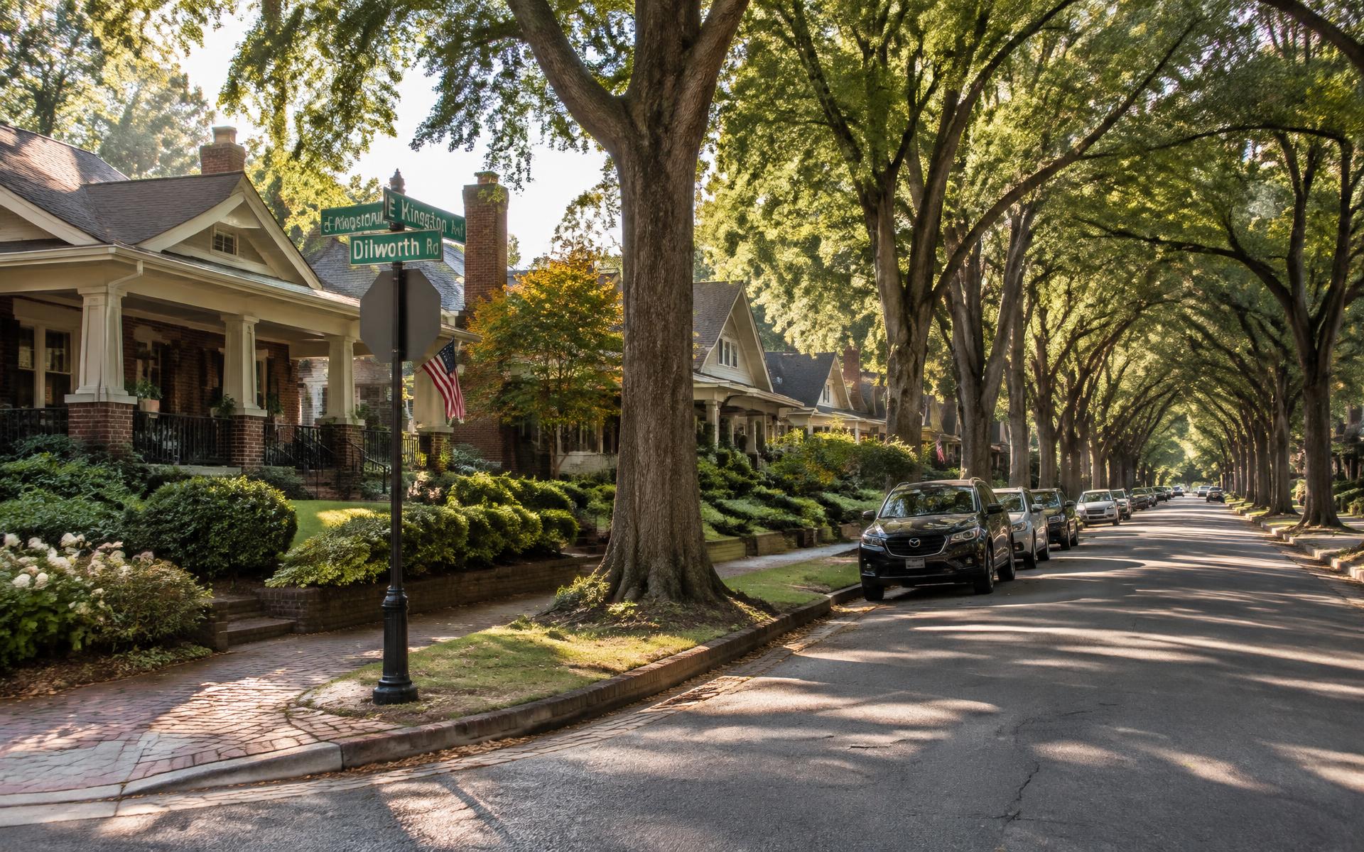
Street by street
Every street in Dilworth, explained
Dilworth is small enough to walk across in twenty minutes and varied enough that two blocks can feel like different neighborhoods. This is the guide to which is which.
Orientation
How the grid is laid out
Dilworth's street plan is the clearest surviving record of how Charlotte built its first streetcar suburb.
The neighborhood reads as a rough triangle. South Boulevard and the light-rail corridor form the western edge, East Morehead Street closes it off to the north toward Uptown, and Park Road with Kenilworth Avenue bound it to the south and east. Inside that perimeter, East Boulevard cuts across the middle as the commercial spine, and everything else is residential.
Because the plan was drawn in 1891 for walking and trolley riding rather than for cars, the blocks are short, the sidewalks are continuous, and the streets curve where the topography asked them to instead of running on a rigid survey grid. That is why Dilworth Road bends, why Lombardy Circle exists at all, and why the neighborhood still feels quieter than its distance from Uptown suggests.
The corridors
The four streets that define the edges
Main street
East Boulevard
North edge
East Morehead Street
West edge
South Boulevard
South and east
Park Road and Kenilworth Avenue
The residential core
Street by street, inside the triangle
These are the blocks people mean when they say they live in Dilworth.
The address
Dilworth Road East and West
Quiet and central
Lombardy Circle
Walk to everything
Scott Avenue
Classic bungalow blocks
Euclid Avenue
Canopy
Kingston Avenue
Southern grid
Ideal Way and Worthington Avenue
Toward Latta Park
Tremont, Springdale and Magnolia
Northern blocks
Cleveland, Berkeley and Rensselaer
What differs
Why one block costs more than the next
Within Dilworth, price tends to track four things more than anything else: how complete the tree canopy is, how much traffic the block carries, whether the house sits inside the local historic district, and how far the walk is to East Boulevard. A renovated bungalow on a quiet interior street with a full canopy will consistently outperform a comparable house fronting a connector road.
Historic district status cuts both ways. It protects the streetscape that makes the neighborhood valuable, and it adds a design-review step to exterior work. Buyers who plan significant changes should confirm district status for a specific address early, because the answer changes the renovation timeline more than it changes the price.
Reading an address
How Dilworth block numbers work
Most address searches here come down to one question: where in the neighborhood is that number?
Numbering climbs away from the Uptown end of the neighborhood. On East Boulevard, the 100 block sits at the northern, Uptown-facing end near South Boulevard; the 700s and 800s fall through the busiest restaurant and retail stretch; and by the 1500s to 1700s the corridor has turned largely residential and institutional as it approaches Kenilworth Avenue. Scott, Euclid and Kingston Avenues follow the same pattern, with the higher numbers sitting toward Park Road and Freedom Park.
A street name alone will not tell you whether a property is inside the local historic district, and a 28203 ZIP will not tell you whether it is in Dilworth or South End. The Mecklenburg County POLARIS parcel viewer and the Assessor's property records settle both: they return the parcel boundary, recorded year built, lot size and zoning for the exact address. Use those before drawing conclusions from a map pin or a listing portal's neighborhood label.
100–600
The Uptown end of East Boulevard
700–1300
The restaurant and retail stretch
1400–1900
The Kenilworth end
Frequently asked
Questions people actually ask
What are the main streets in Dilworth, Charlotte?
East Boulevard is the commercial spine, with South Boulevard and Park Road carrying traffic along the western and southern edges and Kenilworth Avenue along the east. The best-known residential streets include Dilworth Road East and West, Scott Avenue, Euclid Avenue, Kingston Avenue, Lombardy Circle, Ideal Way, Worthington Avenue, Tremont Avenue, Springdale Avenue and Cleveland Avenue.
Source: City of Charlotte
Which Dilworth streets are the most sought-after?
Buyers consistently ask about Dilworth Road East and West, Lombardy Circle, Scott Avenue and Euclid Avenue, largely because of the tree canopy, the depth of the front lawns and the concentration of intact 1910s–1930s houses. Demand also follows how quiet a block is: interior streets with no cut-through traffic tend to hold attention longer than blocks feeding a main road.
Source: City of Charlotte
What is the difference between East Boulevard and East Morehead Street?
East Boulevard runs through the middle of Dilworth as its main street of shops and restaurants. East Morehead Street runs along the northern edge toward Uptown and is dominated by medical offices, the Atrium Health campus and converted professional buildings, so it carries more weekday traffic and far less pedestrian retail.
Which streets in Dilworth are inside the local historic district?
The local historic district covers much of the older core, including large stretches of Dilworth Road East and West, East Boulevard's residential sections and the streets between them. District boundaries are drawn block by block rather than by neighborhood outline, so exterior changes on one side of a street can be reviewed while the other side is not — always confirm a specific address with the city before planning work.
Source: Charlotte Historic District Commission — Dilworth design standards
Are Dilworth's residential streets walkable?
Most are. Sidewalks are close to continuous across the older grid, blocks are short, and the street trees make summer walking genuinely comfortable. The exceptions are the perimeter corridors — South Boulevard, Park Road and Kenilworth Avenue — which are built for vehicle volume and feel far less pleasant on foot.
Source: City of Charlotte
Is parking difficult on Dilworth streets?
It depends on proximity to East Boulevard. Many residential blocks near the commercial strip carry permit-parking restrictions intended to keep restaurant overflow off them, while interior streets are generally unrestricted. Signage is the governing rule and changes block by block, so read it before leaving a car overnight.
Source: City of Charlotte / Mecklenburg County Code Enforcement permitting
Which Dilworth streets have the best tree canopy?
The willow-oak canopy is heaviest on the older interior streets — Dilworth Road East and West, Lombardy Circle, Kingston Avenue and Euclid Avenue among them — where trees planted in the early twentieth century now meet over the roadway. Blocks rebuilt later, or closer to the South Boulevard edge, have younger and thinner canopy.
Source: City of Charlotte
What ZIP code do Dilworth streets use?
Nearly all of Dilworth falls inside 28203, which it shares with South End. A few addresses along the eastern and southern fringes carry neighboring ZIP codes, so verify the exact address rather than assuming the neighborhood boundary and the postal boundary match.
How do Dilworth street addresses and block numbers work?
Numbering on the east–west streets rises as you move away from the Uptown end, so a 100-block East Boulevard address sits at the northern, Uptown-facing end of the corridor while 1700 East Boulevard sits well south, near the Kenilworth and Scott Avenue side of the neighborhood. The same logic applies on Scott, Euclid and Kingston: low hundreds are closest to the north end of the grid, and the numbers climb toward Park Road and Freedom Park.
How do I confirm what is at a specific Dilworth address?
Use the Mecklenburg County POLARIS parcel viewer or the Assessor's property records. They give the parcel boundary, the recorded year built, lot size, ownership and zoning for the exact address, which is the only reliable way to settle whether a property is inside Dilworth, inside the local historic district, or simply shares the 28203 ZIP with South End.
Source: Charlotte Historic District Commission — Dilworth design standards
Which Dilworth blocks are commercial rather than residential?
The commercial frontage is concentrated along East Boulevard between the Uptown end and roughly the Scott Avenue area, with a second cluster of medical and office buildings along East Morehead Street and Morehead Medical Drive. Away from those corridors, the blocks are residential, with occasional corner buildings that predate current zoning.
Source: City of Charlotte Unified Development Ordinance (2023)
Sources & verification
We cite primary sources so you can check our work. Figures, assignments and regulations change — confirm anything you plan to rely on directly with the agency below.
Continue
Keep reading
- East BoulevardThe neighborhood's main street, block by block.
- Interactive Dilworth MapStreets, parks, dining, schools and transit on one schematic map.
- Historic District & Design ReviewWhat local designation actually means before you renovate.
- Architectural StylesReading Queen Anne, Craftsman, Colonial Revival and Tudor details.
Next step
See how the streets fit together
The interactive map puts every corridor, park and landmark described here in one place.